Challenging BECE Social Studies Questions Fully Solved. We have provided answers to some challenging Social Studies questions for BECE candidates. These answers will help you prepare for the upcoming BECE
Take a look at the Challenging BECE Social Studies Questions Fully Solved
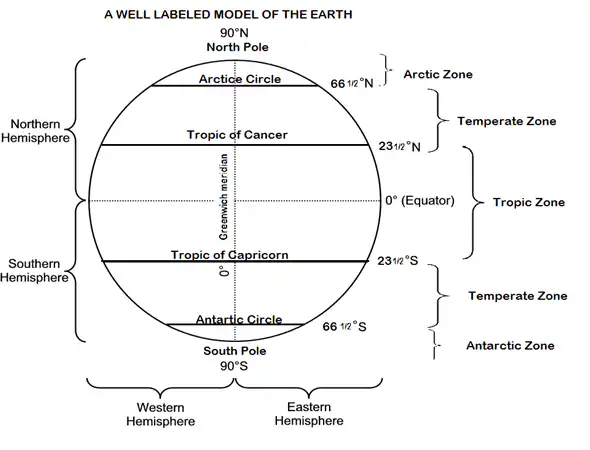
#1. Draw and label the globe
EXCEL IN YOUR EXAMS
Get instant access to the most reliable Mocks and Marking Schemes.
BUY TOP 2026 BECE MOCKS AND ANSWERS
READ: Final 2022 BECE Timetable & Candidates Personal Study Timetable
CHEAP NON-EXPIRING DATA
Buy affordable data bundles that never expire. Reliable and Instant Delivery!
BUY CHEAP DATA NOW
#2. Draw the map of West Africa and locate Ghana on it.
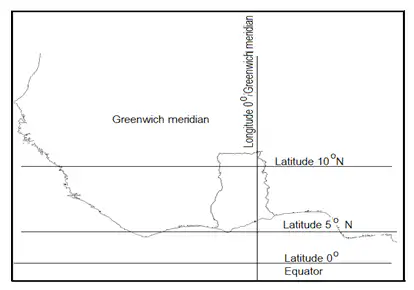
a. Greenwich meridian
b. Latitude 10 degrees North
c. Latitude 5 degree North
d. The equator
126. Explain five benefits of highland to the socio-economic development of Ghana.
i. Mountains including Afaja (885 metres tall) provide very attractive tourist sites and attract tourists from within and outside Ghana. This brings in a lot of foreign exchange and revenue for development.
ii. Mountains serve as a source of rocks that are quarried for road as well as building construction.
iii. Mountainous areas like Amedzofe in the Volta region provide cooler climate for settlement. This attracts a lot of Europeans to such areas each year.
iv. Mountains help in the formation of relief or orographic rain when the mountain forces humid air to rise, condense, cool and fall as rain.
v. Some mountains such as Ejuanema near Mpreaso contain Bauxite mineral resources. Such minerals when mined help provide foreign exchange needed for development.
127. Name lowlands in Ghana and state three benefits of low lands.
Low Lands in Ghana.
j. The Volta lowlands or the Volta Basin lowlands ( From Akosombo to West of Bolgatanga.
k. Costal lowlands in Accra, Shai, Osudoku and Krobo
Benefits
i. Low lying lands or valley provide fertile lands for farming since a lot of plant nutrients are deposited there by rains.
ii. Valleys provide good and conducive place of flow for rivers and streams thereby ruding the occurance of floods.
iii. Valleys serve as good and cheap places for the location or construction of roads since the cost of road construction in such areas are cheap compared to mountainous areas.
Take a look at the Challenging BECE Social Studies Questions Fully Solved
Draw the map of Ghana and locate five rivers
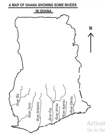
Acronym for rivers indicated (B-TABAAD)
129. Name five water bodies in Ghana which are not rivers.
i. Lake Bosomtwi
ii. Lake Volta
iii. Keta Lagoon
iv. Korle Lagoon
v. Chemu Lagoon
130. Name eighteen rivers in Ghana.
Clue: Acronym for eighteen rivers in Ghana.
(B-TAPAAD TO KNOW KASOA)
River Bia
River Tano
River Ankobra
River Pra
River Amisa
River Ayensu
River Densu
River Tain
River Ofin
River Kulpawn
River Nasia
River Obosum
White Volta
River Kalarakun
River Asuokawkaw
River Sene
River Oti
River Afram
131. Explain five importance of water bodies to the development of Ghana.
a. Rivers like river Ofin and rover Volta provide water for domestic, industrial and agricultural purposes such as washing, cooling of industrial machines and drink for livestock.
b. Rivers like river Pra and Afrom provide home for aquatic animals such as fish and crocodiles.
c. Rivers, including river Tain and river Volta serve as chief source of fish which provides a chief source of protein.
d. Water bodies such as Lake Volta, Ankobra and Pra serve as means of transporting passengers and goods. The Akosombo Queen transports goods and passengers between Akosombo and Yepei in the north.
e. Water bodies like River Oti and river Sene provide a natural means of draining excess rain water thereby reducing floods.
- Differentiate between weather and climate and list five elements of weather.
Weather is the day-to-day atmospheric condition of a place at a given time but climate is the average weather condition of a place over a period of between 30 and 35 years.
Take a look at the Challenging BECE Social Studies Questions Fully Solved
133. With the aid of diagrams describe the two seasons experienced in Ghana or the tropics.
THE WET SEASON
a. Ghana experience only two season; wet and dry seasons because she is located within the tropics.
b. Ghana’s wet season which is caused by the South -West Trade Winds (SWTD) blows from the Atlantic Ocean located South of Ghana.
c. The rainy or wet season in Southern Ghana begins in March and ends in October whiles that of the Northern regions begins in May and also ends in October.
d. The difference in time of rain commencement is because southern Ghana is closer to the Atlantic Ocean than the Northern regions
e. The season is characterized by frequents rains and clouds
f. June and July experience rainfall throughout the day.
g. The occurrence of flood is common as most rivers get filled to their banks and overflow.
h. Temperature may drop to as low as 200 or low due to increased humidity (Wetness in the atmosphere).
i. Ghana’s main or major wet season begins in September and ends in October with August being the coolest month. The map below gives a vivid illustration.
THE DRY SEASON
a. Ghana experiences only two seasons; wet and dry seasons because she is located within the tropics.
b. Ghana’s dry season (Harmattan) which is caused by the North East Trade Winds (NETD) blows from the Sahara Desert in far north of Africa.
c. The dry or Harmattan season of Ghana begins in November and ends in March while that of the Northern regions begins earlier than the south because the Northern regions are closer to the Sahara than the south.
d. The Harmattan is more intense in the North than in the South and there are few or no clouds in the sky.
e. The dry season comes with a lot of dust in the atmosphere.
f. The sun shines the strongest causing a rise in temperature as high as 390 in the afternoons and the drying up of water bodies are common.
g. The weather cools down at night with temperature dropping as low as 200
h. The foggy or blurry weather condition makes visibility at night and down very difficult.
i. The map below gives a vivid illustration.
134. State five characteristics of the Harmattan.
a. The dry or Harmattan season of Ghana begins in November and ends in March.
b. The dry season comes with a lot of dust in the atmosphere.
c. It comes with foggy or blurry weather condition which makes visibility at night and down very difficult.
d. It is blown from the North East to the South West.
e. Cool weather at night early mornings are experienced with temperature dropping as low as 200
135. State four importance or benefits of the dry season.
i. Hunting becomes easy during the dry season.
ii. Malaria and water borne disease fall since water bodies dry up.
iii. Laundry becomes easy as cloths dry quickly.
iv. It provide a good time for the drying of crops like cocoa and maize.
136. Describe how rain is formed.
a. Water bodies get heated on the surface by the sun.
b. Warm air (vapour) rises (Evaporation).
c. Air cools and turns into drops of water (Condensation).
d. Clouds form in the sky and fall as rain.
- With the aid of diagrams describe the three types of rain.
Take a look at the Challenging BECE Social Studies Questions Fully Solved
RELIEF RAINFALL
a. Warm moist air from the sea blows.
b. Warm is forced to rise over the mountains.
c. Air cools as it is forced to rise and condenses.
d. Stratus clouds form in the sky and fall as rain.
e. Leeward side receives little or no rain.

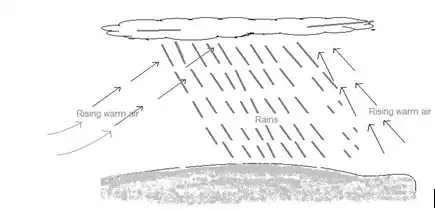
CONVECTIONAL RAINFALL
a. The sun heats the ground which heats the air.
b. Warm air rises on its own convection.
c. Air cools as it is forced to rise and condenses.
d. Cumulonimbus clouds form in the sky and the moisture falls as rain.
e. Convectional rains come with thunder and lightning
f. Convectional rains fall last a while and fall in the afternoons.
CYCLONIC RAINFALL
a. Mass of warm air meets a mass of colder air
b. Lighter warm air rises over heavier cold air.
c. Air cools as it is forced to rise and condenses.
d. Clouds form in the sky and fall as rain.
e. Cyclonic rains fall mostly in the tropics and temperate zones and over wider areas.

138. List four benefits or uses or importance of rain.
a. Rains serve as a good source of water for domestic uses such as cooking, drinking and washing.
b. Rain supports irrigation for the cultivation of crops in the dry season.
c. Rains help cool the atmosphere which makes the weather friendlier.
d. Rains help in the cultivation of a variety of crops during the rainy season.
139. Name five elements of weather and their measuring instruments.
An instrument for Measuring – Element of climate
a. Barometer Atmospheric Pressure
b. Octal Cloud
c. Thermometer Temperature
d. Hygrometer Humidity
e. Wind vane Wind direction
f. Anemometer Wind direction
g. Rain gauge Rainfall
h. Sunshine Recorder Sunshine
Take a look at the Challenging BECE Social Studies Questions Fully Solved
TIPS FOR MULTIPLE CHOICE QUESTIONS
| A drawing showing any part of the earth to scale | Map |
| The model of the earth | Globe |
| Imaginary lines from North to South on the globe | Longitudes |
| Imaginary lines are assumed and don’t exist | Trues |
| Positions or locations of places are known with the help of | Imaginary lines |
| Imaginary lines from West to East are known as | Latitudes |
| Latitude 0 degrees is also known as | The Equator |
| The only imaginary line that divides the earth into two halves –North and south is | The Equator |
| The parallel imaginary lines which do not meet | Latitudes |
| All longitudes meet at two points | The North and south poles |
| The Prime meridian ( Greenwich meridian or First meridian) is also known as | Longitude 0 degrees |
| All longitudes divide the earth into two equal halves | True |
| The earth is divided into two equal halves by | The equator and all longitudes |
| The equator and all longitudes are | Great circles |
| Areas North of the equator | Northern Hemisphere |
| Areas South of the equator | Southern Hemisphere |
| Latitude 66 ½ degrees North | Arctic circle |
| Latitude 23 ½ degrees North | Tropic of Cancer |
| Latitude 66½ degrees South | Antarctic circle |
| Latitude 23 ½ degrees South | Tropic of Capricorn |
| The area between latitude 23 ½ South and 23 ½ North | The tropics |
| Latitude 66 ½ South to the south Pole and Latitude 66 ½ North to the North pole | Temperate Zones |